Saturday 22 December 2012

Khanbulan, Lankaran, Azerbaijan

One more card for today.. and it's my first written and stamped postcard from Azerbaijan! It's such a beautiful view, too, I really like it. I saw some more pictures of Azerbaijan on tv when the Eurovision song contest was held in Baku, but I have to confess I still know very little about this country. Thank you for telling me a bit more, Dilara!


The description on the back of this card reads 'Khanbulan, Lankaran'. Khanbulan is a lake, I think, but I couldn't find much info about it. I wonder if 'Lankaran' refers to the Lankaran Rayon, then. I've already written about the city of Lankaran here, but the Rayon is a separate entity, surrounding but not including the city of Lankaran, which is technically a separate administrative region. The Lankaran Rayon does have a vast area of national parks, where a variety of fauna and flora are preserved.

Sandoy, Faroe Islands

For the longest time I didn't have any postcards from the Faroe Islands - and then suddenly this summer I received two! I'm certainly not complaining, it looks like such a beautiful, fascinating place.


Sandoy is the first of the five southern islands that make up the Faroe chain, the fifth biggest of all the Faroe Islands, an autonomous region of the Kingdom of Denmark. As of 2011, the largest population center on the island is the village of Sandur with a population of 599. Other settlements include Skarvanes, Skopun, Skálavík, Húsavík and Dalur. The island's surrounding bird cliffs and steep slopes have been identified as an Important Bird Area (IBA) by BirdLife International because of their significance as a breeding site for seabirds

On the left on this card you can see a view from Húsavík, an old village located on the east of the Isle of Sandoy. In the centre of Húsavík there is a ruin called ‘Heimi á Garði’. It is said to be the remains of a farm that was built by ‘Lady of the House in Húsavík'. She was a strict and wealthy lady who lived in the 14th century. She owned all the land in Húsavík and also had some properties in Norway. Legend says that she buried two servants alive. It is also said that she got all her wealth, when she sold a golden horn to the king. The story goes that she found the golden horn in the ground, after dreaming of its location.

Bolivia

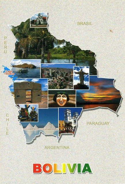
I'm still hoping to receive my first written and stamped postcard from Bolivia, but meanwhile this great mapcard my dear Snježana sent me is still a very nice treat.


Bolivia, officially known as the Plurinational State of Bolivia is a landlocked country in central South America. It is bordered by Brazil to the north and east, Paraguay and Argentina to the south, Chile to the southwest, and Peru to the west.

Prior to European colonization, the Andean region of Bolivia was a part of the Inca Empire – the largest state in Pre-Columbian America. The conquistadors took control of the region in the 16th century. During most of the Spanish colonial period, this territory was known as Upper Peru and was under the administration of the Viceroyalty of Peru, which included most of Spain's South American colonies, although the area enjoyed substantial autonomy under the jurisdiction of the Royal Court of Charcas. After declaring independence in 1809, 16 years of war followed before the establishment of the Republic, named for Simón Bolívar, on 6 August 1825. Bolivia has struggled through periods of political instability, dictatorships and economic woes.

Bolivia is a democratic republic that is divided into nine departments. Its geography is varied from the peaks of the Andes in the West, to the Eastern Lowlands, situated within the Amazon Basin. It is a developing country, with a Medium Human Development Index score, and a poverty level of 53%. Its main economic activities include agriculture, forestry, fishing, mining, and manufacturing goods such as textiles, clothing, refined metals, and refined petroleum. Bolivia is very wealthy in minerals, especially tin. Bolivia has gained global attention for its 'Law of the Rights of Mother Earth', one of the unique laws in the world that accord nature, the same rights as humans.

The Bolivian population, estimated at 10 million, is multiethnic, including Amerindians, Mestizos, Europeans, Asians and Africans. The main language spoken is Spanish, although the Guarani, Aymara and Quechua languages are also common and all three, as well as 34 other indigenous languages, are official. The large number of different cultures within Bolivia has contributed greatly to a wide diversity in fields such as art, cuisine, literature, and music.

Utror Valley, Swat, Pakistan

I received this gorgeous view of Pakistan from the wonderful Vera in a swap earlier this year. I love it how she always writes so much on her cards, and decorates them really beautifully as well. :)


Utror is one of the many side valleys around Kalam in Upper Swat. From Kalam, it is 16km up the Utror River to Utror village, at about 7,300 feet above sea level. It is an unspoilt and peaceful spot and the milky white Utror River flows through the village. The valley provides a base for many trekking opportunities, including many high altitude lakes and summer pastures.

Christchurch, New Zealand

I've got a pretty random selection of cards for today.. next up is this one from New Zealand.


Christchurch is the largest city in the South Island of New Zealand, and the country's third-largest urban area. It lies one third of the way down the South Island's east coast, just north of Banks Peninsula which itself, since 2006, lies within the formal limits of Christchurch. On this postcard you can see one of Christchurch's tramcars travelling the city loop route, passing by the Christchurch Arts Centre. The Arts Centre is one of the many buildings that suffered extensive damage in the 22 February 2011 earthquake.

Bornholm, Denmark

Something slightly less freezing - a great mapcard from Denmark! I think I actually have two copies of this card but I don't mind as it's such a nice card (and the messages are different, obviously).


Bornholm is a Danish island in the Baltic Sea, to the east of most of Denmark, south of Sweden, and north of Poland. The main industries on the island include fishing, arts and crafts such as glass making and pottery using locally worked clay, and dairy farming. Tourism is important during the summer. The topography of the island consists of dramatic rock formations in the north (unlike the rest of Denmark which is very flat) sloping down towards pine and deciduous forests (greatly damaged by storms in the 1950s) and farmland in the middle and sandy beaches in the south.

Udachny, Sakha Republic, Russia

Another snowy view, this time from Russia. This picture was taken in April, brrrr!


Udachny is a town in Mirninsky District of the Sakha Republic, Russia, located 1,370 kilometers northwest of Yakutsk on the Markha River. It has a population of 12,611 (2010 Census preliminary results).

The Sakha (Yakutia) Republic is a federal subject of Russia. Comprising half of the Far Eastern Federal District, it is the largest subnational governing body by area in the world at 3,083,523 square kilometers and the eighth largest territory in the world, if the federal subjects of Russia were compared with other countries. It is larger than Argentina and just smaller than India which covers an area of 3,287,240 km2. It has a population of fewer than one million inhabitants. Its capital is the city of Yakutsk.

The Sakha Republic is one of the ten autonomous Turkic Republics within the Russian Federation. Yakutia also fosters close cultural, political, economic and industrial relations with the independent Turkic states through membership in organizations such as the Turkic Council and the Joint Administration of Turkic Arts and Culture.


I received this card from a swap with Jaroslav who lives in Moldova, hence the Moldovian stamps.

Lappeenranta, Finland

Uh oh.. long time no see. I didn't realise it's been *that* long since I last updated this blog. I don't want to go into details here, let me just say that I haven't really been in the mood for updating this, or doing many other things. I haven't actually sent that many postcards in the past few months, either.. :/ ...and now Christmas is almost here (again)! I'm not very much in a festive mood at the moment and it's not helped by the fact that it's been raining so much for the past few days, and it looks like it's going to be the same over Christmas. I don't normally like snow all that much but it does make the scenery more Christmas-y. :P Therefore I thought I'd post a couple of snowy views of my old hometown Lappeenranta in Finland.


These are actually both Christmas postcards, issued by the local energy company. You couldn't really tell, though, they are REALLY nice. The top one was sent to me and Matt's family by my parents a couple (?) of years ago and shows a view of the harbour, one of my favourite places in the town. The card on the bottom, then, was an official I received in 2009 from a Postcrosser who lives in Lappeenranta! I love coincidences like that :D The picture is from the old fortress, another favourite place of mine and perfect for sliding down the hills with a big bin bag in winters :D (We did that when Matt's family came over some years ago for a visit, hehe.)

Saturday 20 October 2012

City of Luxembourg, Luxembourg

One more card for today.. this one is from a tag in Heather's great postcard group on Facebook. Such a treat, too!


The city of Luxembourg, also known as Luxembourg City, is a commune with city status, and the capital of the Grand Duchy of Luxembourg. It is located at the confluence of the Alzette and Pétrusse Rivers in southern Luxembourg. The city contains the historic Luxembourg Castle, established by the Franks in the Early Middle Ages, around which a settlement developed. As of 2011, the commune of Luxembourg City had a population of 94,034, which was almost three times the population of the country's second most populous commune. The Old Quarters of the city is a Unesco site.

Because of its strategic position, Luxembourg was, from the 16th century until 1867, when its walls were dismantled, one of Europe's greatest fortified sites. It was repeatedly reinforced as it passed from one great European power to another: the Holy Roman Emperors, the House of Burgundy, the Habsburgs, the French and Spanish kings, and finally the Prussians. Until their partial demolition, the fortifications were a fine example of military architecture spanning several centuries.

The City of Luxembourg is located at the crossing point of two major Roman roads. In 963 Sigefroid, a count from the Moselle valley, built a castle on the Rocher du Bock, which he obtained by means of an exchange with the Abbey of St Maximin of Trier. His servants and soldiers settled around the castle and the modern town sprang from the market-place of this settlement, the Vieux Marché.

Mailbox, Guernsey

You know those 'Touchnote' cards that were really popular this summer thanks to the promotion? I received some of them, too, but only sent a couple as I realised too late that you didn't need to have a Samsung phone to be able to send these cards, grrr. :( I really like the idea, although I wouldn't want "normal" postcards to be replaced with these as there's no personal handwriting or real stamps.

Anyway.. one of these cards I received was a surprise from dear Agi in Croatia. Thank you so much!! :)


I particularly like this one as it's mail related, and Agi was clever to choose a picture of a Victorian wall post box in Guernsey - seeing as these cards are being sent from Guernsey. I hadn't realised post boxes in Guernsey are blue, I wonder if they are all like that over there? ..hhhmmmm...

American Indian symbols

A fantastic official card I received from the USA last year. I find this really interesting!

 
US-1346923
 
Info from the back of the card:  

The earliest writings of the American Indians were those of signs and symbols. These symbols are always apparent in their handicraft and jewellery.
 

Yi Peng Festival, Thailand

Another swap postcard from Asia, this time from Thailand. (Apparently this is a handmade card! I would never have guessed! :O)


On this card you can see pictures of Yi Peng Festival. A multitude of sky lanterns are launched into the air where they resemble large flocks of giant fluorescent jellyfish gracefully floating by through the sky. People usually make khom loi from a thin fabric, such as rice paper, to which a candle or fuel cell is attached. When the fuel cell is lit, the resulting hot air which is trapped inside the lantern creates enough lift for the khom loi to float up in to the sky. Looks pretty magical to me!

Cameron Highlands, Malaysia

I've posted about Cameron Highlands here before (and there's been another post about the area since then...) but I just couldn't resist posting this card here as well as I really, really like it, and it's one of those times when I don't mind a card being a multiview *at all*.


In the top left corner you can see the Smokehouse Inn, next to it Strawberry Farm, then Sungai Palas Tea Plantation, and next to that you can see Clipping tea at Sungai Palas. In the bottom left corner you can see Clipping tea at Boh Tea Estate, next to that Orang Asli (Original people) rainforest village, and in the bottom right corner you can see a British phone box at the Smokehouse Inn. It's probably because of the phone box, the inn and the strawberry farm that this postcard doesn't really remind me of Malaysia - it seems very English to me instead! :O

Macquarie Island, Australian Antarctic Territories

This lovely Australian Unesco card was sent to me last year by my postcard pal Sharon. She's sent me some real gems before, including this one. ;)


Macquarie Island lies in the southwest corner of the Pacific Ocean, about half-way between New Zealand and Antarctica, at 54°30S, 158°57E. Politically, it is part of Tasmania, Australia since 1900 and became a Tasmanian State Reserve in 1978. In 1997 it became a World Heritage Site. It was a part of Esperance Municipality until 1993, when the municipality was merged with other municipalities to Huon Valley. The island is home to the entire Royal Penguin population on earth during their annual nesting season. Ecologically, it is part of the Antipodes Subantarctic Islands tundra ecoregion.

Since 1948 the Australian Antarctic Division (AAD) has maintained a permanent base, the Macquarie Island Station, on the isthmus at the northern end of the island at the foot of Wireless Hill. The population of the base, the island's only human inhabitants, usually varies from 20 to 40 people over the year.

Lopinot, Trinidad & Tobago

A wonderful postcard from a recent Facebook swap with Nalini in Trinidad & Tobago. :)


On this card you can see a historical site in Lopinot, a village in Trinidad & Tobago. Doesn't it look beautiful?!

Montserrat W.I.

So much for trying to catch up with this blog... Well, I haven't really been in the mood for updating for a while now (or doing much else.. :/). I thought I'd give this a try now... Starting off with this great postcard of Montserrat that I received via a swap with dear Shinta in Indonesia (so it's not like I have a written and stamped postcard from Montserrat :P Oh well, this is still really nice!).


Montserrat is a Caribbean island that is a British overseas territory. It is located in the Leeward Islands, part of the chain of islands known as the Lesser Antilles, in the West Indies. The island of Montserrat measures approximately 16 km long and 11 km wide, with approximately 40 kilometres of coastline.

On July 18 1995, the previously dormant Soufrière Hills volcano became active. Eruptions destroyed Montserrat's Georgian era capital city of Plymouth and two-thirds of the island's population was forced to flee. The volcanic activity continues to the present, the affected areas currently being mostly in the vicinity of Plymouth, including its docking facilities, and also on the eastern side of the island in the area around the former W. H. Bramble Airport, the remnants of which were buried by flows from volcanic activity on February 11, 2010.

An "exclusion zone" extending from the south coast of the island north to parts of the Belham Valley has been imposed because of the size of the existing volcanic dome and the resulting potential for pyroclastic activity. Presently visitors are not permitted entry into the exclusion zone, but an impressive view of the destruction of Plymouth can be seen from the top of Garibaldi Hill in Isles Bay. Relatively quiet since early 2010, the volcano continues to be closely monitored by the Montserrat Volcano Observatory.

A new town and port is being developed at Little Bay in the northwest of the island. While construction proceeds, the centre of government rests at Brades.

Sunday 16 September 2012

Iceland

I had such a lovely surprise in my mailbox this summer! My French friend Tiphaine and her boyfriend took their mothers to Iceland as a surprise gift for them, and Tiphaine was sweet enough to send me a postcard from there. I had no idea she was going to Iceland! Another friend of mine went there earlier this summer, too - I want to go as well!! :P


Doesn't Iceland look amazing?! The picture in the top left corner shows a church in Skagafjörður in northern Iceland, while the picture in the top right corner is a view from the Þingvellir National Park, which is also a Unesco site. The picture underneath it shows Víti crater by lake Askja, and the one next to it shows the Látrabjarg cliffs. The picture in the bottom left corner shows the Jökulsárlón lagoon, and the one on top of it is the Skógafoss waterfall.

Lofoten, Norway

It's always a treat to receive postcards from Norway, it's SUCH a beautiful country! This card arrived through a swap earlier this year. Thank you so much, Grethe!


Lofoten is an archipelago and a traditional district in the county of Nordland, Norway. Though lying within the Arctic Circle, the archipelago experiences one of the world's largest elevated temperature anomalies relative to its high latitude. It is well known for its natural beauty within Norway.

Lofoten encompasses the municipalities of Vågan, Vestvågøy, Flakstad, Moskenes, Værøy and Røst. The total land area amounts to 1,227 km², and the population totals 24,500. Many will argue that Hinnøya, the northern part of Austvågøy and several hundred smaller islands, skerries and rocks to the east of Austvågøy are also part of the Lofoten complex. Historically the territorial definition of Lofoten has changed significantly. Between the mainland and the Lofoten archipelago lies the vast, open Vestfjorden, and to the north is Vesterålen. The principal towns in Lofoten are Leknes in Vestvågøy and Svolvær in Vågan. The Lofoten Islands are characterised by their mountains and peaks, sheltered inlets, stretches of seashore and large virgin areas. The highest mountain in Lofoten is Higravstinden (1,161 m) in Austvågøy; the Møysalen National Park just northeast of Lofoten has mountains reaching 1,262 m. The famous Moskstraumen (Malstrøm) system of tidal eddies is located in western Lofoten, and is indeed the root of the term maelstrom.

Jabiru stork, Belize

A lovely postcard from Belize I received last year. This was actually my first received written and stamped postcard from Belize, too! Thank you so much, Debbie!


Jabiru stork (Jabiru mycteria). Standing nearly five feet tall and with a 9-12 foot wingspan, the jabiru is the largest stork in Americas.

social media in China

I'm not usually too fond of ad cards as a lot of them are so tacky and boring and well, just seem like adverts for a product or something else I'm not interested in. There are exceptions, however, and this official from China is a great example.

 
CN-689072

This card shows the most popular websites in China and the numbers of members they have. I have to confess I hadn't ever heard of most of these websites so I found this really interesting and informative.

Uglegorsk, Sakhalin Oblast, Russia

My collection of postcards from different regions of Russia keeps growing. :) A while ago I received three gorgeous postcards from the Sakhalin Oblast, this one is probably my favourite.


Uglegorsk District is located on the western coast of Sakhalin. Uglegorsk City is the administrative centre of the district with a population of about 27,200 people. Cape Lamonon is located in this district, too. Sakhalin Oblast is a federal subject of Russia comprising the island of Sakhalin and the Kuril Islands. The oblast has an area of 87,100 square kilometers. Its administrative center and the largest city is Yuzhno-Sakhalinsk. Population: 497,973 (2010 Census). Some territories of Sakhalin Oblast (four islands, the southern ones of the Kuril archipelago) are claimed by Japan.

Ukraine

This card makes me hungry! ..and I really like the colours here, and definitely wouldn't say 'no' to one of those embroidered towels. So pretty!


In the first picture you can see borsch in the pot, in the second picture berries of snowball tree. In the third picture you can see pretty embroidered towels, and in the fourth picture vareniks, stuffed cabbage fritters. The sender, Anna tells me there are potato vareniks as well. Mmmmmm...! They look a bit like the Polish pierogi (which I still haven't tried even though they're sold in lots of places here as there are a lot of Poles living in this area).

Kraków, Poland

A wonderful official I received from Poland earlier this year. This card was in my favourites, too! It's always nice when people look at the favourites wall. I always do that, too, but don't always have anything from some people's favourites :(

 
PL-379104

On this card you can see Tram No. 15 on its way to the Cichy Kącik estate in Kraków. I just love the atmosphere here, so mysterious! ...and I love trams, they have so much more character than buses or trains I think.

bicycle, the Netherlands

The Netherlands seems to have an endless supply of bicycle postcards... which suits me just fine as I love them! :) This one is from a favourites tag on the Postcrossing forum this summer.


I don't have much to say about this card expect that I really, really like it. The Anne Frank graffit is brilliant!

Istra, Croatia

I'm trying to catch up with this blog a little so it's time for another update. This lovely map card is from a swap with Adi in Croatia earlier this year. I love the shape! :D


Istra is the largest peninsula in the Adriatic Sea. The peninsula is located at the head of the Adriatic between the Gulf of Trieste and the Bay of Kvarner. It is shared by three countries: Croatia, Slovenia, and Italy.

Saturday 15 September 2012

Tea Pickers, West Java, Indonesia

This is a really old postcard, received back in 1997 from Terhi who used to be my penpal way back then. She moved to Indonesia for a couple of years as her dad got a job there, and she sent me some postcards from there which I still have (I probably have all her letters still somewhere, too, as I don't like throwing mail away). I don't think I used email too much back then as Terhi sent me this card to let me know of her new address...


I don't have much to say about the card itself, and the text on the card pretty much says it all. I'm not sure if I've ever had tea from Indonesia, btw... I'm going to need some extra cups of the stuff this weekend as I've managed to catch a cold, ugh. :/

Petra, Jordan

A WONDERFUL card I received from a swap recently. Thank you so much for this treat, Luca! This is also my first received written and stamped viewcard from Jordan - I did already have a postcard sent from Jordan (thanks to dear Astrid) and I really like it, too.


Petra is a historical and archaeological city in the Jordanian governorate of Ma'an that is famous for its rock-cut architecture and water conduit system. Established possibly as early as 312 BC as the capital city of the Nabataeans, it is a symbol of Jordan as well as its most visited tourist attraction. It lies on the slope of Mount Hor in a basin among the mountains which form the eastern flank of Arabah (Wadi Araba), the large valley running from the Dead Sea to the Gulf of Aqaba. Petra has been a UNESCO World Heritage Site since 1985.